New Zealand’s first line of defence against volcanic eruption is an unassuming collection of buildings on the Waikato River just north of Taupō. Our scientists take a classic number-eight-wire approach, as Matthew Martin reports.
Apart from a rather serious-looking security fence, the GNS Science Wairakei Research Centre looks deceptively normal.
It’s definitely not your stereotypical movie-set science base – there are no space-age buildings, flashing lights or security guards, and there’s not a white lab coat in sight.
A pair of transportable offices are set up as a reception area with some older buildings nearby, at least one of which is closed due to asbestos contamination.
Behind the row of reception buildings lies a barbed wire and electrified chain link fence housing the ominous-sounding Zone 13, where the real science happens.
Plonked in the middle of an active geothermal field in the shadow of Mt Ruapehu, you could not pick a better place to study and monitor New Zealand's volcanic wonders.
In fact, our guide Dr Agnes Mazot, a volcanic gas geochemist originally from Lyon, France, says New Zealand is a “paradise for volcanologists”.
Mazot has studied volcanoes in Italy, Mexico, Indonesia, and the Pacific Islands and has been working for GNS for 13 years.
Her area of expertise is gas; specifically the volcanic and hydrothermal gases released by volcanoes and how they can be used to interpret what is happening under the surface.
“The gas is a very important part of looking at seismicity and magma deformation,” Mazot said.
“We look at what’s coming out of the magma and the three main gases, carbon dioxide (CO2), sulphur dioxide (SO2) and hydrogen sulphide (H2S) – the one that smells like rotten eggs.
CO2 is a sign of deep degassing more than 10km down, and can be an early warning signal that magma is rising.
“They’re like an open window of what’s going on down there.”
During volcanic alert level 2 Mazot is often up in a plane flying over the mountain weekly or fortnightly, depending on the mountain’s underlying activity.
There’s a number-eight-wire feel to the volcanic centre.
Open office doors reveal gumboots, backpacks and hiking gear, but not a white lab coat in sight.
The SO2 gas sampling system the scientists use dates back to 1996 and needs at least two people to carry it, although it’s about to be replaced with a modern handheld version.
“It’s a correlation spectrometer, it’s old, but it works really well,” Dr Mazot reassured us.
The spectrometer fits into an approximately 10cm-wide hole in an aeroplane door that also happens to be sitting in the corner of the same room.
The scientists take the door with them, so it can be fitted onto the aeroplane they are using on the day.
Scientists often have technicians build unique pieces of equipment designed specifically for use in their individual fields of research.
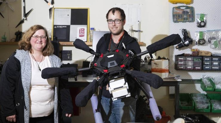
Senior operations technician Cam Asher is part of GNS’s Remote Infrastructure Management Team – his office is an electronics workshop filled with cable ties, plastic piping, old drones, monitoring gear and other random pieces of tech.
Asher builds and maintains GeoNet earthquake monitoring sites, and also specialises in unmanned aerial vehicle and drone technologies, plus the visual and gas monitoring of volcanoes.
He completed a Master’s degree studying volcanic lichen, and has worked in a variety of places including Antarctica.
Technicians are adept at repurposing commercial technology for their own purposes, such as a remote-controlled boat Asher is working on which will house equipment designed to carry out tests on Ruapehu’s crater lake (Te Wai ā-moe) as well as some basic sonar gear.
“It will drive around and collect depth data, so we can identify if there’s a dome or something building under the water.”
“I build the stuff, they test the stuff, break the stuff and I fix the stuff again,” Asher said.
Every Monday a team of scientists from around the country meets to discuss their latest findings, and decide on the week’s programme of monitoring work.
They also consider any changes to alert levels on the volcanoes they monitor, including Ruapehu, Tongariro and Whakaari (White Island) – with heightened scrutiny during periods of increased volcanic activity, as has been seen in recent weeks.
The practical side of the job also sees staff trained for situations they could encounter in the field, including training and safety courses for first aid, what to do when a helicopter or aeroplane crashes, mountain safety courses, abseiling.
Asher, who shares Mazot’s enthusiasm for the field, said the varied range of tasks kept things interesting at work.
“I think I’ve got a pretty good job.”
What is GNS Science?
GNS Science (Te Pū Ao) is officially known as the Institute of Geological and Nuclear Sciences and is a Crown Research Institute that focuses on geology, geophysics – including seismology and volcanology, and nuclear science – particularly ion-beam technologies, isotope science and carbon dating.
The organisation dates back more than 150 years and was originally known as the New Zealand Geological Survey, founded in 1865.
New Zealand’s Crown Research Institutes were formed in 1992, when GNS Science became the umbrella organisation for the Department of Scientific and Industrial Research (DSIR) and the Institute of Nuclear Sciences.
“Since 1865 we have demonstrated scientific excellence in a country that straddles two tectonic plates, where earthquakes were first associated with geological faulting, and whose first Nobel Laureate, Ernest Rutherford, saw that radioactive isotopes could be used for geological dating,” its website states.
GNS has almost 400 staff based in three main locations, with Avalon, Wellington employing three-quarters of them, Wairakei with about 80 and around 20 staff based in Dunedin.
Along with its government research contracts it also works with the private sector providing consultancy services, product development and analytical services.
Credit: Stuff.co.nz